Why Cities Keep Revising Their Maps of Movement
Why cities revise maps of movement: learn how everyday trips reveal access gaps and help planners choose practical changes to walking, transit and services.
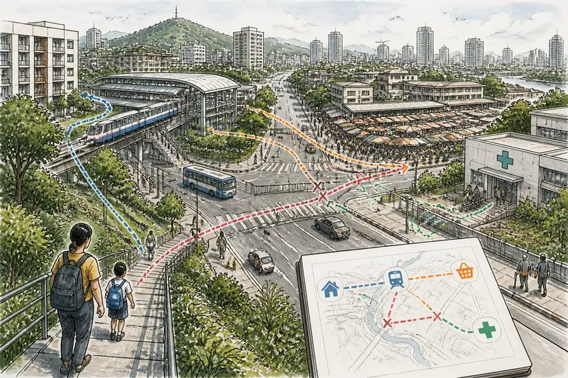
The common mistake in a city map of movement is treating the route people were expected to take as the route they actually take. That mismatch can leave a new station poorly connected to nearby homes, or a busy market separated from its customers by a road that is difficult to cross. Revising maps of movement means asking where daily trips really go and what gets in their way.
A movement map describes connections, not just roads
A conventional street map shows physical features: roads, rail lines, rivers and buildings. A movement map adds relationships. It asks which homes connect to which workplaces, schools, clinics, shops and public spaces, by what modes, and with what changes along the way.
Planners can represent those relationships as lines between places, with points marking destinations or transfer locations. The lines need not mean a single direct trip. A worker might walk to a bus, change to a train, then walk again. The map can show that chain, including where a long wait, an awkward transfer or an unsafe crossing makes the connection less usable.
This distinction matters because a city can have abundant infrastructure and still offer poor access. A railway may pass close to a neighborhood without a convenient entrance. A public destination may be nearby in distance but separated by a wide road, a steep slope or a boundary that funnels people toward one crossing.
Everyday trips expose gaps between planned and lived networks
Plans often begin with designated routes, land-use maps and forecasts of where growth is expected. Daily movement adds a different kind of evidence: where people choose to go, where they detour, and which destinations remain difficult to reach. The point is not that every observed route should become a new road or transit line. Recurring patterns can instead reveal a connection planners did not account for.
Useful evidence may come from pedestrian counts, transit boarding and transfer records, street observations, community meetings, travel diaries or anonymized mobility data. Each source has a blind spot. Counts show volume at a location but may not explain a trip’s purpose. A meeting can surface specific barriers but may not represent everyone who uses the area. Phone-based data can miss people who do not carry or share a device.
Comparing sources helps distinguish a persistent access problem from a temporary change. A busy path might reflect a market day, a construction detour or a regular commute. Planners also need to ask whose movement is absent from the data: children, older residents, people with disabilities, shift workers and people whose trips involve several stops rather than one home-to-office journey.
Route choices show how destinations depend on one another
Movement is rarely a simple line between a home and a job. A trip may connect a school drop-off, a workplace, a food market and a clinic. If the map considers only the largest destination, it can miss the short links that make a day workable. Those smaller connections can matter as much as a major corridor, particularly where transit requires walking between stops or changing services.
Say planners are reviewing a fictional district with new housing near a rail station and a public clinic across a busy road. In this invented situation, they begin with three inputs: a sketch of the homes, station and clinic; observations of the sidewalks and crossings; and residents’ descriptions of their usual routes. They trace the direct route and the longer route people describe, then note where each crosses traffic, loses sidewalk continuity or meets the station entrance. If the direct route ends at a road with no usable crossing, the likely decision is to examine a pedestrian link or intersection change; if the crossing works but the station entrance sends walkers away from the clinic, planners can review access and service layout instead. The expected observable result is a route map that shows a continuous, usable connection—or makes clear which barrier remains—not simply a new line on paper.
Before changing a route or facility, planners can use this checklist. Each observation points to a decision, with an alternative if the evidence suggests another cause:
- Check whether the destination is correctly located. If the clinic, school or station entrance is mapped at the wrong access point, correct the location first; if it is accurate, inspect the route between destinations.
- Check whether sidewalks connect along the route. If the path ends or narrows into an unusable section, assess a continuous walking link; if it remains connected, examine crossings and access points.
- Check where people cross the road. If observed routes depend on a difficult or indirect crossing, review the intersection or crossing location; if crossings are usable, look for a barrier elsewhere on the journey.
- Check whether the mapped route matches residents’ accounts. If people consistently take a different path, map that path and ask what it offers; if accounts vary, gather more local observations before choosing a permanent change.
- Check whether transit access is part of the gap. If the walking route reaches the station but not a usable entrance or transfer, review station access and service connections; if transit access works, focus on the street link or destination.
- Check whether the pattern persists beyond a temporary disruption. If it appears tied to construction or a market-day diversion, record the condition and revisit the map after it changes; if it recurs in ordinary conditions, consider a lasting response.
The map therefore helps planners see places as a connected service network. A workplace district may depend on reliable links to affordable housing and childcare. A waterfront park may serve several neighborhoods only if paths into it are continuous. These connections can cross administrative borders, so the useful planning unit is sometimes the journey rather than the district boundary.
Revisions become useful when they change a decision
A map is not a verdict. It is a way to frame choices. Once a weak connection is visible, planners can compare responses: adjust a bus route, improve a walking link, change the location of a crossing, coordinate service hours, or place a public destination closer to the people it serves. The appropriate option depends on the cause of the gap, not on the visual drama of a line on a map.
Revision also needs a clear question. Is the aim to shorten a transfer, make a school route more accessible, connect a residential area to jobs, or improve access to a clinic? A broad aim such as “better mobility” is too vague to guide a decision. A focused question lets planners gather relevant observations and explain why one connection deserves attention before another.
It is not worth the effort to redraw a map after every short-lived detour or treat every popular shortcut as permanent demand. Temporary events, seasonal conditions and construction can distort a snapshot. A map earns its keep when a pattern recurs, the people affected can describe the barrier, and the resulting change can be checked in ordinary use.
What should planners ask before revising maps of movement?
How is a movement map different from a transit map?
A transit map emphasizes routes and stations in a transport network. A movement map can include walking, cycling and the destinations people are trying to reach, so it shows whether the full journey connects rather than only whether a service passes nearby.
Can planners use mobility data on its own?
They can use it as one source, but it may omit people or fail to explain why a route was chosen. Pairing it with local observation and input from affected residents gives planners context before they propose a change.
Why do maps change after a project opens?
New housing, workplaces, services or transit links can alter where trips begin and end. Once people use the new network, planners can see which connections work as intended and where daily routes still involve an avoidable detour.
How can residents contribute useful information?
Residents can identify the destination they are trying to reach, the route they usually take and the specific point where the trip becomes difficult. A precise account, such as an inaccessible curb or a crossing that does not connect to the sidewalk, is easier to evaluate than a general request for better access.
Maps should follow people across changing neighborhoods
As neighborhoods change, the relationships between homes, work and public destinations change with them. A movement map gives planners a way to revisit those relationships without assuming that a line of infrastructure automatically creates access. Its main value is practical: it makes the journey visible enough to ask what is missing, who is affected and which change could make the connection more usable.
That is why cities keep revising their maps of movement. The map should not preserve an old plan for its own sake; it should reflect how people now reach the places that sustain daily life. For anyone searching how cities revise maps of movement, the useful question is not only where people go, but what the route asks them to overcome.